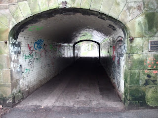
Hows that for a back gate? by where the Taiglum Burn joins the Water of Coyle
Sheep keeping their feet dry,off the flood plain.
Back where we were yesterday
Our Pooh Sticks bridge!
Sad to see the Mill o'Shiel farmhouse derelict.
we traced as near as we could the lead to Millmannoch from the weir we saw yesterday. It follows the contour naturally, and you can see the line coming towards the road along the hedgeline across the field on the right.
The line is just to the left of the hedge and comes almost to the road, where it doubles back and heads directly away from the corner of what was a field,now a mass of brambles and blackthorn. a hundred metres or so along it ran into the mill dam with a sluice to the mill. Before our walk we looked at the 1909 Ordnance Survey map of Taiglum, which became Drongan in the 1930s when most of Taiglum was demolished. It is getting interesting spotting surviving buildings.
We missed most of the rain.
They are now measuring how much the earth is moving...
This stretch of road didn't get the same reinforcement five years ago that the next stretch up did...and the gabions do look rather shaky. There is also 15 to 20 feet width of bank until the river, so it isn't undercutting it (apart from when it floods)
The Pelton Wheel that was the corn mill's update in the 1940s I think...but the door was shut and the key turned finally in 1970
overflow and lead to the wheel on the right
and over the road the lead still traceable, and after the snow and rain, still wet!
View of Arran from Arran View...a well named house.
We're packing and weighing, hopefully we'll be way under the weights for the Emirates, and wont have to pay excess to Air Chathams...although their rates are a tenth of the big boys!!


